


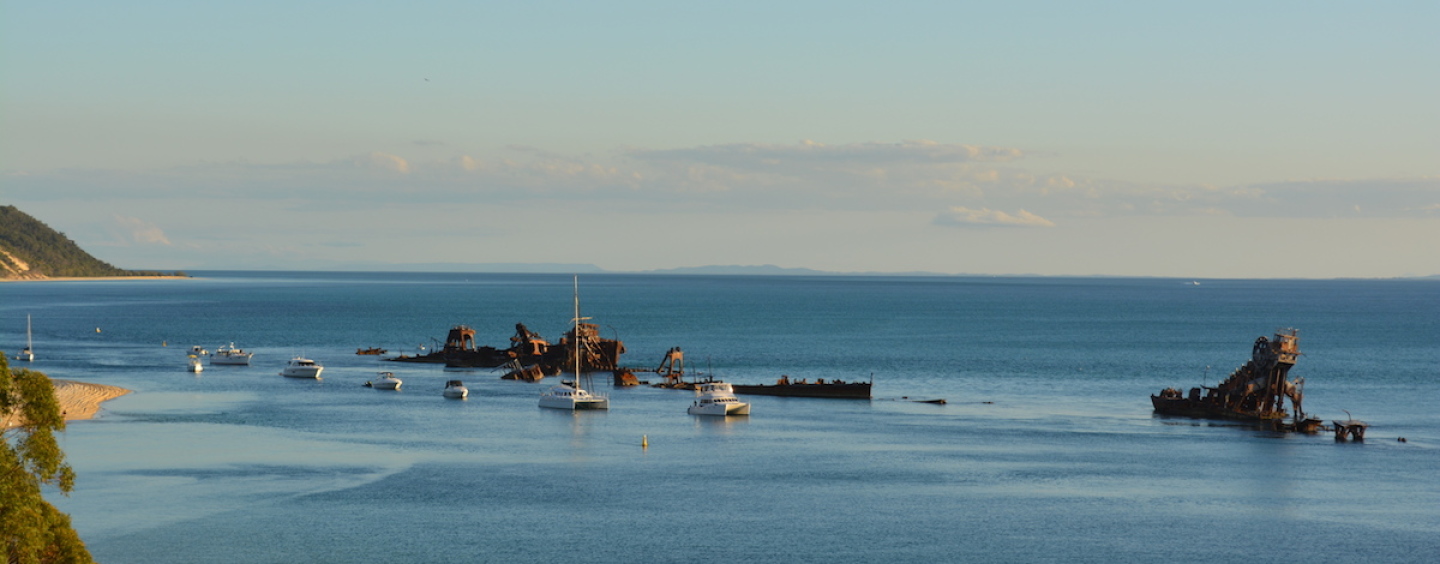
“A friend of mine had never been to Tangalooma before, so that was a good enough excuse!” Nic Welch sets off on a long boat journey from the Gold Coast full of a great adventure documenting his journey for our readers. He outlines all the best things to do and see as the Tangalooma wrecks provide a surreal backdrop to overnight stays with amazing sunsets across Moreton Bay.
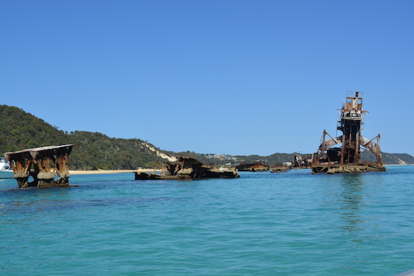
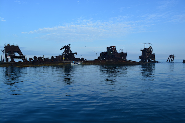
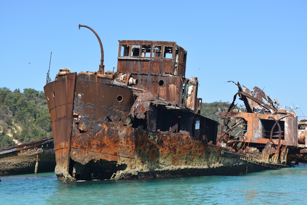
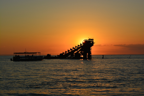
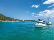
Tangalooma was originally a whaling station. Later on, the Tangalooma Island Resort was built on the site of the old whaling station. The relics of the original whaling station are a feature of the resort. The wrecks—now also a popular dive spot—were placed there to create an anchorage for vessels so boaties can drop anchor right beside the wrecks. These anchoring sites are in high demand, so it is best to arrive midweek to secure your spot.
The wrecks at Tangalooma on Moreton Island lie halfway between Cowan Cowan Point and Tangalooma Point. Unfortunately, there is not much protection against the predominant summer north-easterlies or predominant winter south-easterlies. Westerlies during winter can also cause a very uncomfortable night if sleeping on board your vessel. Having said that, if you are visiting the wrecks for diving, then winter offers the best water clarity.
Travelling There
Depending upon the weather and the design of your vessel, allow two days to travel from the Gold Coast to Tangalooma, spending a night at Peel Island. Also, allow another two days for the journey home, plus two to three spare days in case the weather turns bad and you are unable to return on the day you planned.
A word of warning: When you travel to and from Tangalooma, your vessel will enter the shipping lanes of the Port of Brisbane. Ships have the right of way over all other vessels due to their restricted maneuverability and deep draught. They cannot alter course easily and take many kilometres to come to a complete stop. Never anchor in shipping channels and always give them a wide berth when passing. Always travel off the plane when in go-slow zones as turtles and dugongs are prevalent in Moreton Bay.
NOTE: Can we do an illustrated map with arrows on this one? (showing where Peel Island is, Rainbow Channel to Amity, Rous Channel, Tangalooma, etc)
A recommended route is to travel from the Gold Coast up the Southport Broadwater and Canaipa Passage via Tiger Mullet Channel and Five Ways, then spend the night on the southern side of Peel Island. Choose Canaipa Passage as it is more scenic than travelling up the Main Channel on the western side of Russel Island. Canaipa Passage also offers greater protection from the wind.
The shortest path from Peel Island to Tangalooma is to head northwest from Peel Island to near Harry Atkinson Artificial Reef, and then head north towards Tangalooma Point. If you are not in a rush, head up the Rainbow Channel to Amity on North Stradbroke Island, then west down the Rous Channel at South Passage Bar before following the five-metre depth contour north along Moreton Island, taking in as much of the scenery as possible.
For large vessels, Horseshoe Bay on the southern side of Peel Island is suitable as it offers great protection in north easterlies. Lazaret Gutter on the northern side of Peel Island offers protection from south easterlies although it is a narrow channel and swing room can be of concern. Please note Peel Island has coral everywhere and great care should be taken when navigating around the island.
In south easterlies, vessels with a deep draught should consider anchoring between Macleay Island and Karragarra Island instead, or behind Canaipa Point on Russel Island. Another option is to anchor at One Mile at Dunwich.
Camping. On South Stradbroke Island, there are camping grounds at South Currigee, North Currigee, and Tipplers. The next campground north is at Peel Island. Alternatively, you can camp on North Stradbroke Island at Adams Beach (Dunwich) and at Amity. There is also holiday accommodation available at Dunwich and Amity. Heading north, the next campground is at Tangalooma wrecks. Resort accommodation is available at Tangalooma Wild Dolphin Resort. North of Tangalooma, there are campgrounds at Ben-awa and Comboyuro Point.
Canaipa Passage, which runs alongside North Stradbroke Island and Russel Island is a beautiful stretch of water. Slipping Sands at the southern end of the passage is worth a stop, as is climbing the steep Mt Willes (134 metres high) on North Stradbroke Island at the northern end of the passage for spectacular views of the passage and Moreton Bay.
Peel Island, named after being a leper colony in the colonial days, is also a beautiful island with white sandy beaches in Horseshoe Bay, and worth a snorkel around the coral, which surrounds the island.
There are massive sandbanks in Moreton Bay, particularly around the Rous Channel, which runs between North Stradbroke Island and Moreton Island. You are guaranteed to see heaps of turtles and dugongs. For this reason, many of these sandbanks are regulated as “go-slow zones” to avoid propeller and hull strikes on these slow moving marine animals. The “go-slow zones” extend to either a two-metre or five-metre depth contour depending upon location.
The “Little” and “Big” Sand Hills towards the southern end of Moreton Island are a highlight. If you have time, walk across the narrowest part of Moreton Island at the Little Sand Hills, which is only two kilometres across. Just make sure you bring heaps of drinking water with you (and a camera!).
If you have a slow vessel, troll a lure. You never know what you may catch.
Re-Fueling
There are on-water fuel stops available at Horizon Shores Marina and Rudy Maas Marina at Woongoolba north of Jacobs Well, Raby Bay Marina at Cleveland, and Royal Queensland Yacht Squadron at Manly Boat Harbour. There are also land-based service stations located on Macleay Island, Russel Island, and at Dunwich and Amity on North Stradbroke Island. The only fuel available on Moreton Island is at the general store in Bulwer, five nautical miles north of the wrecks, and is sold in 20L containers. The closest on-water fuel location to Tangalooma is at Scarborough Marina, 14 nautical miles due west across the bay. Moreton Bay is notorious for its short steep chop, which can easily double your fuel consumption. Also consider the extra weight in cargo you will undoubtedly be carrying on board. The direction of the tide also plays a significant part in the amount of fuel used. It is over 50 nautical miles one way by water using the shortest path from the Gold Coast Seaway to Tangalooma. Double the amount of fuel you expect to use, and then carry a further third more as spare.
Things to do at Tangalooma
Set anchor between the wrecks and the shoreline. In a north-wind direction, it is calmer to anchor just south of the wrecks. In a strong northerly, it is slightly better to anchor south of Tangalooma Point close to shore. Likewise, in a strong southerly it is better to anchor north of Cowan Cowan Point. There is a no-anchoring zone between the yellow markers to the north of the wrecks, where the vehicle ferry MICAT lands on the shoreline. For smaller vessels, there is a campground with toilets and showers just behind the tree line opposite the wrecks. Small vessels can pull up on the beach overnight. Just be aware that 4WD vehicles use the beachfront as a road, and therefore you should not have a long anchor rope; otherwise, it will be a hazard for vehicles.
The best way to view the wrecks above water is to drift alongside them using a small dinghy or a kayak. It is highly advisable not to climb on the wrecks. If you do snorkel or dive the wrecks, you will be amazed at the underwater aquatic life. There are tropical fish (such as emperor angelfish and moon wrasse) and hard corals that can be found on the Great Barrier Reef, along with other species, such as trevally, harmless wobbegong sharks, turtles, bream, snapper, luderick, morwong, butter bream and giant flathead resting under the wrecks.
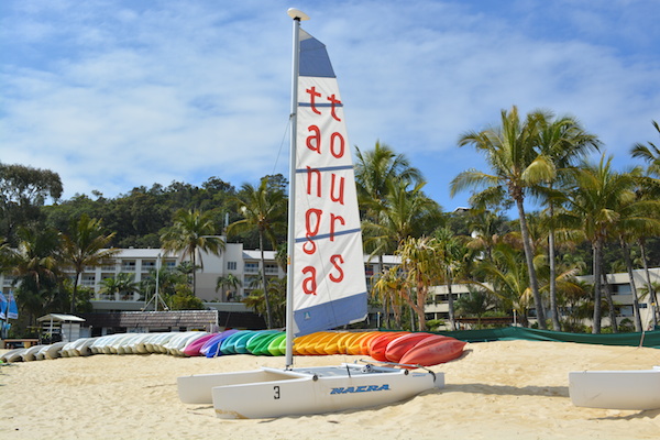
Climbing the giant sand hill at False Patch (at the wrecks) is a must do, although there are signs advising against this due to the instability of the dune. The view from the top across Moreton Bay is amazing, and is quite spectacular at sunset. Sliding down the dune on a piece of cardboard or boogie board is great fun too! The evening wild dolphin feeds at the resort are famous and resort guests have an option to swim with the dolphins.

7 things you cannot do without:
- A VHF radio allows you to monitor shipping traffic in the area.
- Check that all your safety gear is in working order and stored in an easy-to-reach location, including flares that are in date.
- Carry all the tools required to fix any mechanical problems, plus tools to fix any electrical issues, including spare fuses.
- If required, purchase dry ice and block ice for the esky too, and plenty of drinking water.
- Evenly distribute the weight in your vessel, and secure loose items by lashing them down. Moreton Bay is notorious for its short steep chop. A 20-knot wind will easily produce 1m+ chop in the bay. The last thing you need is attempting to lash down loose items in bad seas.
- Remember to take a good pair of binoculars. Navigation marks in Moreton Bay can be several kilometers apart, and almost impossible to see with the naked eye.
- Boaties can use a map (Beacon to Beacon Guide) and a compass at the very least. A GPS is fantastic tool to have on board. However, it only takes an electrical fault, water ingress, loose wire, flat battery, corroded connector, or a blown fuse to render your GPS useless and place your vessel in potential danger. An up-to-date paper chart and a liquid-damped compass are virtually failsafe navigation tools.


