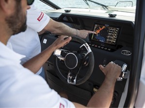
The latest Simrad®App debuted recently for the marine electronics leader celebrating its 75th anniversary. The updated app includes a premium offering complete with new mapping features, advanced functionality and mirroring and control of Simrad®multi-functional displays from your smartphone or tablet. It is available on both the Apple Store for iOS and Google Play for Android.
Radar (an acronym for Radio Detection And Ranging) provides you with a different viewpoint from that seen by your eyes. In poor visibility conditions, it reveals what would otherwise be invisible or barely discernible, from prominent features like landmasses and ships to smaller ones such as buoys, small craft, and even sea birds in calm conditions.
It is equally helpful on a clear day in broad daylight, providing you with the tools to accurately gauge your distance and bearing from a navigation mark or headland. Due to the lack of visual references, it can be hard to accurately judge distance by eye at sea.
Radar’s ability to monitor relative position over time is invaluable in collision avoidance – avoiding close contact with ships and other hazards.
WHAT IS RADAR?
As it traditionally evolved, radar sends out electromagnetic pulses from a rotating magnetron at the speed of light. Objects are detected by measuring the direction and time these pulses bounce back if they hit a reflective target.
Today’s generation of Simrad®radars offers a significant improvement in performance by using pulse compression and CHIRP (Compressed High-Intensity Radiated Pulse) technologies. They provide exceptional performance with enhanced definition and also dramatically reduce radio emissions. These advances are made possible by the use of modern micro-electronics.
The kind of radar image achievable now on small boat radar would have been unimaginable on the largest ship not so many years ago.
RADAR ENABLES YOU TO:
‘See’ what might otherwise remain invisible at night and in poor conditions such as mist and fog
Monitor your distance and bearing from ships, boats, buoys and land masses
Cover blind spots at the wheel
Provide a useful cross-check with other navigation data
RANGE
The range of a radar is very much like a marine VHF. Its transmissions must be ‘line of sight’ where the radar antenna and target must be ‘visible’ to each other.
The earth’s curvature is a factor, so the height of the radar antenna (or radome) is essential. For example, if your boat’s antenna is at the height of 5m and the object you are detecting is also at the height of 5m, then the theoretical maximum range is 18km (just under 10 nautical miles). If you were seeking a 10m high target, the distance would increase to 22km (12nm).
There are quite a few reasons why the anticipated range is not achieved. The shape and material of the objects you are trying to detect may not reflect well. Sea conditions will play a part as water is a good reflector. A heavy rainstorm may reflect the radar pulses and disguise a target in the middle of the downpour. That can be useful of course, in terms of detecting squalls.
The reflective nature of water helps in other ways. Small objects such as plastic buoys that might otherwise not reflect may do so at short ranges in calm seas because they are wet or cause disturbance in the water around them.
ADVANCED FUNCTIONS AND FEATURES
Modern developments have provided the user with much more sophisticated control. One excellent example of the abilities of modern radar is the dual-range function that you’ll find on Simrad®Halo radars. Dual-range allows users to monitor short and long-range images side-by-side, something previously requiring two radar sets to achieve. It can be hard to keep perspective if constantly zooming up and down ranges – dual-range solves that by allowing you to simultaneously monitor short and long ranges.
Even the smallest radars now typically have advanced collision avoidance functions once only seen on big ship bridges. The term MARPA means Mini Automatic Radar Plotting Aid. The ‘mini’ part relates to MARPA being a simplified version of ‘ARPA’ used on big ship radar. MARPA enables you to automatically track several targets to monitor their progress and ascertain whether they might become dangerously close if you maintain your current course and speed. The latest Simrad®radars build on MARPA by having advanced features such as VelocityTrack™, which uses Doppler technology to provide instant visual feedback through coloured trails. The radar calculates if the targets are approaching or moving away from your vessel and colour them yellow approaching and green diverging (depending on the chosen palette) to provide instant visual feedback on which targets pose a collision threat.
ZoneTrack™ provides more valuable collision avoidance information such as Closest Point of Approach (CPA) and Time to Closest Point of Approach (TCPA) and vessel speed and heading as soon as the target enters a predefined zone. Combined with VelocityTrack and AIS, you have the ultimate in situational awareness and collision avoidance at a glance.
‘Dangerous Target Alert’ warns the operator of dangerous radar and AIS targets according to parameters that the operator sets. ZoneTrack™ and Dangerous Target Alert are currently only available on Halo Domes. You can read more about the advanced features on Simrad®radars in our Radar – your extra pair of eyes feature.
WHAT WOULD I USE MY RADAR FOR AND WHEN?
Collision avoidance
Navigating safely in poor visibility and at night
Cross-referencing other navigation information
Covering blind spots from the driving position
Watching out for extreme weather events like squalls
Detecting fish activity (by spotting clusters of sea birds)
If you have a radar fitted, we recommend you use it all the time.
To learn more or to request a SIMRAD installation, contact www.aseamarine.com.au
Published in print July-September 2023


