


Thanks to satellite navigation and electronic instrumentation, the mariners of today live in privileged times. You can easily say that there is a genuine over-reliance on GPS and Chartplotters. Indeed there are now many examples of people’s blind faith in the system, careless plotting at the wrong magnification and inability to read the instructions or clarify what certain terms mean, like ‘No information available’. So when things go wrong at sea, which they always do, it’s important to be able to navigate using some of the more traditional methods.
Throughout the Asia-Pacific region there are just so many reefs, or “bricks” as they are commonly referred to. It is not just racers or cruisers who have to be aware – it is everyone, and both power and sail.
The U.S Navy had what we would call a minesweeper run straight up on the Tubbataha Reefs in the Philippines. How so? Well the ship’s electronic charts misplaced a reef by eight miles! Yet, right there on the good old paper versions, the reef was clearly marked, and wouldn’t you know it, exactly where it should have been! Seems the Officer-in-Charge of the USS Guardian at the time told the navigator to trust the electronics, because they were newer and updated. The ship was ruined and then had to be cut up, so as to avoid doing more damage to the reef. The US Government also had to pay out their Filipino counterpart. BTW, the officer in question and all above him were relieved of duty.
So then, if you think the black box always has the correct answer, then you might want to think about getting in touch with your inner, ancient mariner. It is sound practice before you are faced with unreliable fixes, system shutdowns or own incapacitation due to illness or injury on board.
Now getting back to basics should not have your head in a spin. The following should make it a lot simpler, and you won’t need a sextant, celestial charts, tide tables, or scrounge around for a radio direction finder. To get started, source yourself these items:
- Paper charts
- Dividers
- Lead pencils and sharpener
- Parallel rulers
- A magnetic compass
- Binoculars
Navigation 101
You should partake of a reputable course from a licensed provider to relearn the basics of navigation. But in the meantime, kick-start your rusty skills by following these tips:
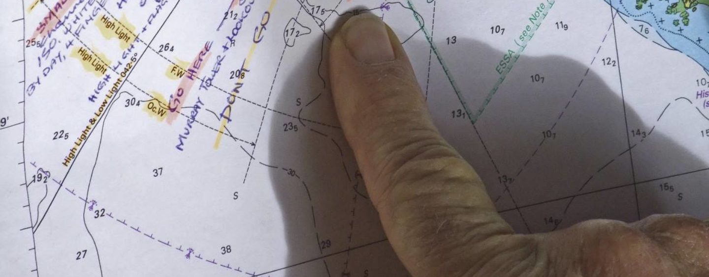
Practise navigating using a paper chart. When cruising in open water, plot your course by drawing a line from point A to point B. Use your dividers to measure the distance by using the degrees and minutes scale on the East or West borders of your chart (the Latitude, which is almost consistent up and down the entire globe). This way, you can estimate your cruising time by dividing the distance by your cruising speed in knots.
Verify your course direction. Use parallel rulers to ‘walk’ your course line over to the centre of the Compass Rose to calculate your Magnetic Course. Read the annual magnetic variation in the notes, and adjust it accordingly.
Know how to correct your compass for variation and deviation. This is a necessity for properly steering your boat from point A to point B. The easiest way to remember the conversion process from magnetic to true degrees, is to apply this mnemonic: “Can Dead Men Vote Twice At Elections” (Compass, Deviation, Magnetic, Variation, True, Add East.). So, when converting compass heading to true heading, add East deviation and variation, then you subtract when it is West deviation and variation. If that one is too hard to remember, try the easy one – “East is least and West is best” to help you remember which to subtract and which to add to.
Alternatively, to convert from true to compass, use this mnemonic: “T. V. Makes Dull Children All Ways” (True, Variation, Magnetic, Deviation, Compass, Add West.). Thus, when converting true heading to compass heading, you add West deviation and variation, but subtract East deviation and variation.
Check your progress periodically. As you cruise using your GPS Chartplotter, watch the electronic course line and compare it to your paper chart course line. At regular intervals, record your latitude and longitude, and then plot onto the paper chart to confirm your advancing location.
Note that when cruising where there is a water flow — either a river current or an ocean tide — please keep in mind that the GPS Chartplotter will show SOG, actual Speed Over Ground. This is an adjusted speed accounting for your vessel slowing in the face of a flow, or accelerating when running with the water.
Use binoculars—and pack a spare. (Lovingly known as the ‘Big Eyes’) Always practice situational awareness by knowing where you are at all times. Take advantage of charted landmarks, like silos, water towers, VORTACS and overhead power cables. As the USS Guardian neared the reef, personnel on the bridge reported flashes from a lighthouse. But those were ignored as the crew continued to rely on the electronic charts and GPS. It would have been a good time to plot the reciprocal on a chart and get an accurate fix, but we shan’t go there.
Also, pack a separate pair of binoculars for the navigator and captain. You have different sets of eyes and won’t need to readjust the focus each time you pick them up to see your next buoy or day marker.
Stay ‘steady as she goes’. Now, some like to use Post-It notes or removable coloured tabs to keep track of where they are or to highlight your final destination. Problem is, they are removable. Try to use the pencil and actually make a plot and record the time, and so if you cannot contact the authorities in the event of a disaster, someone else will be able to provide the information. It is also way more than handy if the electronics go down, which of course never happens at sea…NOT!
Pantaenius Sail and Motor Yacht Insurance is here to help you enjoy your boating and get the most out of it. In a way, it is part of the all-risk policy that Pantaenius has covered you with. So if you have a question, search the site at www.pantaenius.com.au, or call +61 2 9936 1670 and speak with one of the crew who really know boats.
Original material by Chris and Alyse Caldwell (captainchrisyachtsservices.com)
Revised and adapted by John Curnow


